
“The technological revolution influences the practice and training of future civil engineers, architects and urban planners in the construction industry.”
Hard Hat Mack is a video game published in 1983 by Electronic Arts where a construction worker performs tasks, fleeing from the supervisor, clearing obstacles that fall, like bolts and moving beams. In retrospect, I cannot consider this childhood video game as a first call to the construction field. However, undeniably, I became excited to participate in large engineering projects from the design phase to their materialization, which is a significant motivator for those who choose disciplines related to construction.
Even in the early stages of training future civil engineers, architects, and urban planners, students visit job sites and do practices that allow them to put their “boots” on the ground and experience their career practically as soon as possible. However, the pandemic made such experiential practices impossible due to the access and mobility restrictions imposed by the authorities. How can students develop the competencies declared for professional practice remotely? How can they obtain detailed information about a place without measuring it in person?
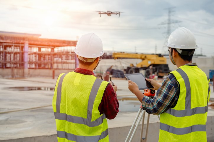
“Despite the restrictions due to the pandemic, the students managed to obtain an immersive experience of the physical spaces studied from any exterior angle, using technologies such as drones, photogrammetry techniques, and laser scanning or terrestrial LIDAR.”
Given the accelerated growth of cities, graduates of the Build Environment area face significant challenges developing skills to systematically analyze the territory’s functioning and propose integral solutions for orderly, sustainable, and inclusive urban development. Thus, it becomes vital that the students understand, from early stages in their training, the environment of the project and the interactions of the variables that define it.
Characterization of the environment with technology
The pandemic’s restrictive measures and confinements made on-site inspections difficult or impossible. An alternative was to use Google Earth and Street View to tour the work areas. However, the images do not necessarily capture the project site, are outdated or have insufficient resolution to obtain precise measurements in construction projects. Faced with this reality, Professor Arnold Pacheco launched a drone and, with photogrammetry techniques, obtained a three-dimensional model of the Clouthier Linear Park, located in Santa Catarina, Mexico, which he shared for use in his scheduled courses.
Because of their accessibility and autonomy, drones can document construction project progress and photogrammetry to generate digital elevation models, orthophotos, and other outputs.
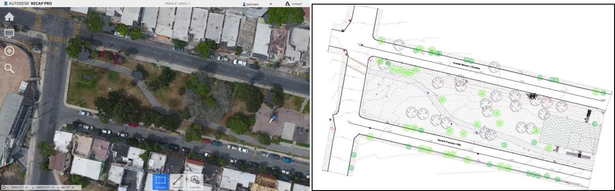
Image 1: 2020 point cloud model of Clouthier Linear Park (left) and student plan (right).
The experience was rewarding for teachers and students. The point cloud allowed students a three-dimensional visualization of most of the physical spaces. The navigation was done with point cloud management software with student licenses for Autodesk’s Recap. They used from home and could measure the environment to generate topographical and overall plans. We had survived the first onslaught of the pandemic; however, we needed to act if the situation persisted.
From this experience, we also observed that the model had its limitations. Depending on the characteristics of the drone and the flight parameters, photogrammetry typically provides an aerial or plant perspective of the project. However, the facilities or construction under wooded areas, bridges, etc., were hidden, preventing their identification.

Image 2: Areas under trees with missing information from the photogrammetry point clouds; images were taken by the drone over Clothier Linear Park 2020 (left) and integrated view with the drone and terrestrial scan of Spring Valley Park 2021(right). Self elaboration.
We resorted to a second sensor: laser scanning or terrestrial LIDAR to reveal the facades of archaeological monuments and industrial facilities or other applications to solve this limitation. This technology is relevant due to its ease of use and the speed to acquire millions of points detailing the surfaces. With this idea, we formed a multidisciplinary work team with professors from Tecnologico de Monterrey (Monterrey and Guadalajara campuses) and professionals from LabSIG who applied to the Novus Fund 2020 call to finance the project.
Building and deploying virtual models in the class
From September 2020 to February 2021, we took on the task of planning, executing, and processing the drone’s photogrammetric surveys and the terrestrial scanning of several buildings on the campuses, a park, and San Juan Bosco Church located in the Tec District. The parish priest, Brother Alejandro Beltrán Garza, kindly allowed us access inside the church to do interiors exercises when all the public spaces were closed.
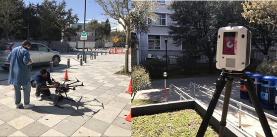
Image 3: Field survey 2021. Drone flight Arizona Building (left) and ground scan LAD Building (right).
The integration of the point clouds obtained by both sensors offered more than 260 students an immersive experience of the workspaces, letting them visualize the physical space from any exterior angle exterior and interior angle in the church model’s case. In addition, students could identify the cooling systems on the roofs, irrigation valves, sewers, and other elements at ground level obscured by the treetops. As with the previous model, when the surveys were carried out per topographic processes, it preserved the ability to extract information about the geographical position, dimensions, and elevations with the appropriate precision to elaborate topographic and overall plans.

Image 4: Model of San Juan Bosco Church 2021 exterior (left) and interior (right).

Image 5: Arizona Building Model 2021 (left) and plan made by students (right).

Image 6: Model of Tec Rectory 2021 (left) and extract of the plan made by students (right).
This work made it possible to develop competencies in students despite the constraints of the pandemic. Although using models does not replace the learning process involved in managing surveying equipment and performing field activities, it significantly enriches the information that can be represented due to the virtual survey. Also, this experience shows the student how the technological revolution impacts practices in the construction industry. Here is when Hard Hat Mack goes virtual in pandemic times and will undoubtedly continue to evolve.
These results were obtained within the framework of the Novus ID-N2020-194 Fund: “Virtual models: Integration of multi-sensor point clouds to develop competencies in the Build Environment.”
I invite professors who work in areas related to construction to share their learning experiences through the Observatory of the Institute for the Future of Education of Tecnologico de Monterrey.
About the author
Laura M. Yeomans (lyeomans@tec.mx) has been a professor in the Department of Sustainable and Civil Technologies since 2001. She has taught courses at the undergraduate professional and master’s level in Hydrology, Geomatics, Geographic Information Systems, and Environmental Engineering. Since 2008, Laura has coordinated the Geomatics Laboratory and the Sustainable Water Use Laboratory. She has participated in consulting projects of Tecnologico de Monterrey related to the diagnosis and treatment of industrial wastewater and the hydrological analysis and modeling of basins, also serving as director of the academic program of Civil Engineering at Tec.
Edited by Rubí Román (rubi.roman@tec.mx) – Observatory of Educational Innovation.
Translation by Daniel Wetta.
Novus is an initiative of the Institute for the Future of Education that seeks to strengthen the culture of educational innovation based on evidence in the professors of the Tecnológico de Monterrey. To do this, we provide funds to implement educational innovations and their impact measurement. We seek to disseminate, transfer, and scale the projects and their internationalization through peer-reviewed publications, conferences, and international competitions.
Our purpose is to encourage experimentation and research in educational innovation as a means for the professional development of the faculty, the continuous improvement of its teaching practice, and the construction of the future of education.
For more information, visit: https://novus.itesm.mx/
Facebook: https://www.facebook.com/novusitesm
Twitter: https://twitter.com/novustec_